As had most of our Alaska tour since leaving Nome, Thursday June 5th dawned bright and clear. We gobbled down breakfast and climbed in the van for a trip to Exit Glacier, whose terminus is fairly close to Seward.
 |
| Visitor's Center at Exit Glacier. |
Exit Glacier is part of the Harding Icefield, and comes down off the mountains to the north. Its outwash plain feeds Exit Creek, which drains into Bear Creek, and on to Resurrection Bay. This is the only part of Kenai that is accessible by car, and there are two trails--one leading the glacier itself, and another leading up to the Harding Icefield.
 |
| Map of the Seward/Exit Glacier area. |
While we were looking for birds here (the Grey-cheeked Thrush comes to mind) I was much more interested in the scenery, which was as usual spectacular. It seems you can't be anywhere in the southern two-thirds of Alaska without having snow-capped mountains within view.
As with most glaciers these days, Exit is in retreat. There were signs everywhere--made-made as well as those left by the glacier itself--that showed its past. Rock scoured and scored by the glacier's push were visible throughout the area.
 |
| Glacier-scoured rock. |
As the glacier retreats, plants slowly fill in the bare areas left behind. You can read about plant succession here, but in a nutshell, as the glacier retreats the first plants to move in are mosses and lichens, followed by herbaceous plants. These help anchor the thin soils while adding humus. Next shrubs appear, once there is enough soil to support them, and then trees will become established, usually fast growing, short-lived species first, followed by longer-lived species. In the photo below you can see areas of bare rock nearest the glacier, where plants have yet to get established, followed by low vegetation and then shrubs.
 |
| Exit Glacier from a distance. Note the bare rock still surrounding the glacier. |
Several things served as a stark reminder of the glacier's retreat. One was this sign, which marked the glacier's terminus just 20 years ago.
 |
| No glacier here! |
The other is this sign, which is also a PDF currently downloadable from the National Park Service. It shows the glacier's tip reaching the outwash plain, but now the tip of the glacier barely reaches the end of the trail (see where it says "Edge of the Glacier" middle left). It has also shrunk considerably side to side.
 |
| The glacier now only reaches to where this graphic says "Edge of the Glacier" |
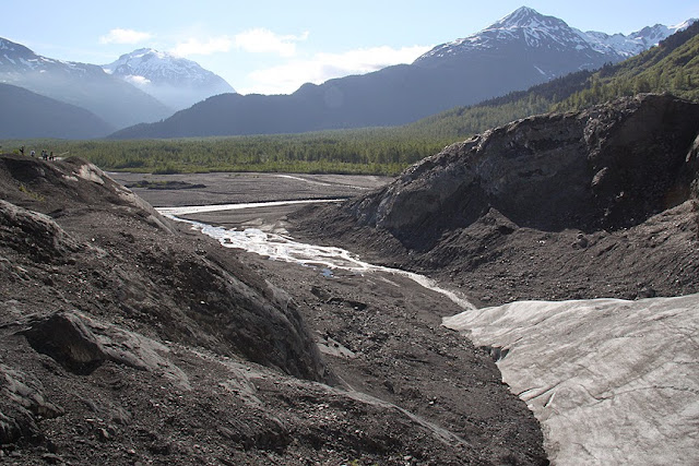
We hiked up the trail to the edge of Exit Glacier, and there it was, looking somehow forlorn. There was a tremendous amount of melting going on, creating some whitewater in the streams leading to the plain.
 |
| The terminus of Exit Glacier. |
I hung back from the group, as I often do, looking a little closer at the landscape. I like this image for scale. The end of the trail brings you within about 50 feet of the edge of the glacier.
 |
| Birding at the glacier's edge. |
Finally I made my way to the end of the trail.
 |
| Exit Glacier up close. It was not that long ago that it filled this entire valley. |
Once again, I was gobsmacked.
 |
| Terminus to outwash plain to Exit Creek. |
Next: We drive from Seward to Wasilla, with a few stops along the way.

No comments:
Post a Comment