
For those unfamiliar with Isle Royale, it is located in the north-west corner of Lake Superior. While it is only about 20 miles from the shores of Minnesota and Canada, it is officially Michigan territory. It holds a long history of human presence, mostly involved with the mining of copper. Both Native Americans and Europeans mined the island, with some pits dating back 5700 years. Logging and mining by Europeans and Americans left the island badly scarred, but once it was established as a National Park in 1940 those activities ceased, and the island began to recover.
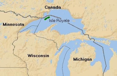 |
| Isle Royale National Park in relation to Michigan. How in the heck did we end up with it?? |
During the copper mining years many homes were built on the island as well as several resorts, primarily in proximity to Rock Harbor. Families who owned property on the island when it became Federal land were allowed to lease their property for as long as whichever family member whose name was on the lease lived. Today there are still a handful of properties with active residents, all of whom were children when their leases were signed, but most of the homes are empty. The Park Service tore many down over the years, but more recently a push has been made to preserve the structures for their historical significance. The Isle Royale & Keweenaw Parks Association works with the National Park Service to maintain the buildings, one of which is used for the Artist-In-Residence program.
Most of the island is now designated a wilderness area, although the area surrounding Rock Harbor and its shops and lodge is not. Most of the homes do fall within the wilderness, so there are some limitations as to what can be done to and around the homes. Cutting of trees is a big no-no, unless they threaten the stability of the structures. Our work focused primarily on painting, re-roofing, debris removal and some minor structural repairs. Major work, like shoring up foundations, is done by professionals. I'll talk more about the island as we make our way along this journey.
That journey began for me on Sunday June 9th, 2013, a day after I did a show in Kalamazoo. My original plan had been to drive all day Monday to Houghton, in the Keweenaw Peninsula, where the Ranger III departs for Isle Royale. A friend convinced me to leave Sunday if I could (it's a 10 hour drive) and the more I thought about it the better that idea sounded. If I could get across the Mackinaw Bridge Sunday, I would have time Monday to do a little exploring across the U.P.
I crossed the Mighty Mac around 7:30 in the evening, and stopped at the Straits State Park in St. Ignace. It's a nice campground with a gorgeous view of the bridge, but it's loud there as you hear all the traffic noise.
 |
| The Mackinaw Bridge from Straits State Park |
I slept in the back of the van, which made getting in and out of the campground pretty painless. I was on the road Monday by 6:30 am, and drove west on US 2, which runs along the southern shore of the U.P., on Lake Michigan. I had never been farther west on US 2 than M-77, which runs north to the Seney National Wildlife Refuge, so I decided to drive over to Manistique, then take M-94 north towards Marquette. It was a little out of the way, but I wanted to do some sightseeing.
 |
| Eastern UP. This is an updated map as I had the wrong location for Wagner Falls. The hazard of waiting six months to write about something! |
I pulled off at a nice little roadside park in Manistique and took the obligatory lighthouse photo, then walked down to the beach.
 |
| The Manistique Light |
The shoreline along Lake Michigan varies here in the U.P. Much of it is sandy, but then you come across these areas where it's all sandstone. I was fascinated by how it brakes into rectangular chunks.
 |
| Manistique beach. |
There were a great number of Common mergansers in the area.

From Manistique I drove north towards Marquette, planning to stop and see Wagner Falls, then head into town to have lunch at one of the best darn restaurants anywhere, Sweet Water Cafe. I had noticed a National Forest campground on the map off of M-94 and stopped for a look and a few quick photos. I say quick because the mosquitoes were just horrific. I must have had 20 follow me into the van. It would be a wonderful place to camp--but maybe not in June.
 |
| Indian River, Hiawatha National Forest |
I reached Wagner Falls around noon, and the parking area was pretty full, but by the time I got my camera and had applied a liberal coating of bug spray, several people had left. As I made my way towards the falls, two more groups passed me, and by the time I reached the falls I was all alone.
 |
| Tiny falls downstream. |
I wasn't there at the best time of day as far as the lighting goes, and I was without a tripod, but I made the best of what I had and managed to get a few long exposures by resting the camera on the boardwalk railing.
 |
| Wagner Falls |

I stayed for 10 or 15 minutes, enjoying the sounds of rushing water, Red-eyed vireos and solitude, while the mosquitoes nibbled my ankles, which were exposed when I squatted to take pictures.

Next: Second half of my drive across the U.P., with a stop at Laughing Whitefish Falls.
what a wonderful place I have never been near there and bow I want to go!!
ReplyDeleteI think the whole UP is spectacular. Very wild feeling.
Delete